
Hydrographics PowerPoint PPT Presentations
All Time
Recommended

Wash parts. Dipping Process. Step 1. Dissolving. Step 2. Dipping. Step ... Automotive. Bibliography. Title Page. www.dalteckinc.com/finishing/hydro.htm. Outline ...
| PowerPoint PPT presentation | free to view

1888 PressRelease - Whether you're looking for a striking design to adorn your automobile or wanting a specific print and protective coat for the stock, grip and barrel of your firearm, Tampa Hydrographics Facility is ready to assist with customized, personalized coating needs.
| PowerPoint PPT presentation | free to download

I. Hydrographical profile (h.pr. ... Taking a hydrographical profile (1) ... Evaluation of the hydrographical profile (1) ...
| PowerPoint PPT presentation | free to view

A Company in the NIVA-group Modelling of environmental impact of aquaculture hydrographical models
| PowerPoint PPT presentation | free to download

A Company in the NIVA-group Modelling of environmental impact of aquaculture hydrographical models Modelling objectives Reach a better understanding of ...
| PowerPoint PPT presentation | free to download

(1888 PressRelease) Tampa Hydrographics Facility provides affordable, custom-designed water transfer printing and firearm coatings for automotive and gun enthusiasts across the Tampa Bay region.
| PowerPoint PPT presentation | free to download

Training on Hydrographic modelling technique. Bangkok, Thailand, May 16-22, 2002 ... AS21 Study on the SEA-Basin hydrographical modelling on a watershed runoff model. ...
| PowerPoint PPT presentation | free to download
Total Hydrographic - We deliver custom solutions based on the marine projects working alongside project managers, engineers, dredge operators, and port authorities.
| PowerPoint PPT presentation | free to download

A hydrographic survey is the process of mapping, measuring and describing features that affect marine activities, including navigation, offshore drilling and exploration, marine construction and other related areas
| PowerPoint PPT presentation | free to download

We will look at the critical role hydrographic services play in protecting coastal populations from disasters.
| PowerPoint PPT presentation | free to download

we'll dive into the world of hydrographic survey services, shedding light on what they are, why they are important, and how they work. So, let's set sail on this informative journey to uncover the secrets of hydrographic surveying in a simple and engaging way. Know More: https://www.falconsurveyme.com/our-services/bathymetric-survey/hydrographic-survey-2/
| PowerPoint PPT presentation | free to download

If you're looking to understand the actual exam or identify your weak spots on the exam questions then we recommend you go through the practice test. This practice test is a web-based test that simulates the test interface. In addition to evaluating your preparation for test questions you also have the chance familiar yourself with the real exam.
| PowerPoint PPT presentation | free to download
An underwater survey looks at a variety of features. It is sometimes referred to as underwater surveying. Topographic characteristics, sea depths, and tide data are being studied and investigated. For a variety of practical reasons, knowing and understanding the curves and heights of ocean beds is essential. Bathymetric surveys are another name for hydrographic survey services. For more information about our Hydrographic Survey please visit : https://www.falconsurveyme.com/our-services/bathymetric-survey/hydrographic-survey-2/
| PowerPoint PPT presentation | free to download

Hydrographic services are related to the measurement, description, and charting of the physical features of bodies of water, including their depths, tides, currents, and other characteristics. Falcon Survey Engineering Consultants offers these services, which are used for many things, such as navigation, transportation, resource management, monitoring the environment, and scientific research.
| PowerPoint PPT presentation | free to download

The global hydrographic survey equipment market size is expected to grow from $2.45 billion in 2021 to $2.63 billion in 2022 at a compound annual growth rate (CAGR) of 7.3%.
| PowerPoint PPT presentation | free to download

The hydrographic survey market was valued at US$ 97.19 million in 2019 and is projected to reach US$ 155.91 million by 2027; it is expected to grow at a CAGR of 6.2% from 2020 to 2027.
| PowerPoint PPT presentation | free to download

The global hydrographic survey equipment market size was valued at USD 2.95 million in 2021. It is projected to reach USD 4.89 million by 2030, growing a CAGR of 5.8% during the forecast period (2022–2030). For more info - https://straitsresearch.com/report/hydrographic-survey-equipment-market
| PowerPoint PPT presentation | free to download

Total Hydrographic our hydrographic surveying solutions are based on a wide range of specialized technologies and expertise to offer data that is usable and reliable.
| PowerPoint PPT presentation | free to download

In the last few years, several fishing ports were designed at convenient locations, thereby eliminating the need to scrutinize environmental factors such as uncharted reefs, wave heights, and water depth and tidal stream changes. Several marine structures were expanded across the globe, and numerous issues that used to be considered minor have now grown into major ones. Read More: https://bit.ly/3qAaPMS
| PowerPoint PPT presentation | free to download
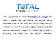
Total Hydrographic are your certified Hydrographic Surveyors and Marine Mapping/GIS professionals. Bathymetry is the study and mapping of the sea floor. Bathymetric surveys allow for us to measure the depth of a body of water as well as map its underwater features.
| PowerPoint PPT presentation | free to download
We are the best hydraulic survey company that estimates the water depth of the onshore or offshore marine environments that include waterway planning, dredging analysis, and wreck location.
| PowerPoint PPT presentation | free to download

Ocean surveying is one of the best ways that helps to determine underwater areas features. All the details, such as - water depth, topographic features, measurements of tides, etc., are entirely appropriately covered under Ocean Survey.
| PowerPoint PPT presentation | free to download

The global hydrographic survey equipment market is projected to grow from USD 2.07 Billion in 2016 to USD 2.74 Billion by 2022, at a CAGR of 5.39% from 2017 to 2022 during the forecast period.
| PowerPoint PPT presentation | free to download

The hydrographic survey market was valued at US$ 97.19 million in 2019 and is projected to reach US$ 155.91 million by 2027; it is expected to grow at a CAGR of 6.2% from 2020 to 2027. Get Sample Copy:-https://bit.ly/3gSH30t
| PowerPoint PPT presentation | free to download

Multibeam Echosounder Survey is our specialty at Yolax Infranergy. we provide all types of hydrographic survey to suit any project need, including multibeam bathymetry, side-scan sonar and subsea metrology. Our multibeam echosounder provides imaging and mapping capability of high resolution in deep/shallow water systems. multibeam echosounder transmit sound waves from directly beneath a ship's structure to deliver fan-molded inclusion of the ocean bottom. MBES has a more than one transducers that enable a substantial swath of area to be surveyed at once making studying a lot quicker and more accurate. For more Info - http://www.yolaxinfra.com/echosounder.php Email - info@yolaxinfra.com
| PowerPoint PPT presentation | free to download

Total Hydrographic - Hazard Detection and Debris Clearance is a necessary support service for any organisation that manages a body of water. It is crucial to identify new or existing obstructions from natural or anthropogenic events, and to determine safe recreational use for the public.
| PowerPoint PPT presentation | free to download
Ocean surveying is one of the best ways that helps to determine underwater areas features. All the details, such as - water depth, topographic features, measurements of tides, etc., are entirely appropriately covered under Ocean Survey.
| PowerPoint PPT presentation | free to download

Evapotranspiration Concepts and Irrigation Water Requirements Thomas W. Ley PhD, PE Chief Hydrographer Colorado Division of Water Resources Background Education ET ...
| PowerPoint PPT presentation | free to download

Direct Runoff Hydrograph
| PowerPoint PPT presentation | free to view
Hydrologic Analysis Dr. Phil Bedient Rice University Hydrologic Analysis Dr. Phil Bedient Rice University SCS RAINFALL RUNOFF CURVES Unit Hydrograph Applications Land ...
| PowerPoint PPT presentation | free to download

Title: A CCOM Python Tutorial Author: Kurt Schwehr Last modified by: Kurt Schwehr Created Date: 10/31/2006 12:10:47 AM Document presentation format
| PowerPoint PPT presentation | free to download

Synthesis of Unit Hydrographs for Texas Watersheds Theodore G. Cleveland, UH William H. Asquith, USGS David B. Thompson, R.O. Anderson Xing Fang, Auburn University
| PowerPoint PPT presentation | free to view

Hydrographic Survey Equipment Suppliers in Dubai UAE? we provides the Best ROV tooling Suppliers, Marine Solutions, Seismic Solutions, Designed Solutions & Geotechnical Equipment Suppliers in Dubai UAE. Contact Now MER-Subsea
| PowerPoint PPT presentation | free to download

stream flow and rainfall runoff
| PowerPoint PPT presentation | free to view

Find the Best Marine & Hydrographic Survey Equipment Suppliers in Dubai UAE? Contact Mer-subsea.com we provides the Best Environmental Equipment Suppliers, ROV tooling Suppliers, Marine Solutions, Seismic Solutions, Designed Solutions & Geotechnical Equipment Suppliers in Dubai UAE
| PowerPoint PPT presentation | free to download

Required: Readings: 16-1 to 16-9.1 &16-9.5 Figures: 16-1 to 16-4. Recommended, not required, extra readings: Hydrographic Surveys section 16-12.
| PowerPoint PPT presentation | free to download

Find the Best Marine & Hydrographic Survey Equipment Suppliers in Dubai UAE? Contact Mer-subsea.com we provides the Best Environmental Equipment Suppliers, ROV tooling Suppliers, Marine Solutions, Seismic Solutions, Designed Solutions & Geotechnical Equipment Suppliers in Dubai UAE
| PowerPoint PPT presentation | free to download

Evaluation of Natural Resource Management: Watershed Hydrology, a Hawaiian Prospective Ali Fares Associate Professor of Watershed Hydrology Moisture in Atmosphere!
| PowerPoint PPT presentation | free to download

Hydrograph simulation for a rural watershed using SCS curve number and Geographic Information System Dr. S.SURIYA Assistant professor Department of Civil Engineering
| PowerPoint PPT presentation | free to view
![Hydrographs[Date] Today I will: - Be able to construct and understand flood hydrographs PowerPoint PPT Presentation](https://s3.amazonaws.com/images.powershow.com/8256383.th0.jpg)
Hydrographs [Date] Today I will: - Be able to construct and understand flood hydrographs Higher Geography Hydrosphere Higher Geography Hydrosphere What is a hydrograph?
| PowerPoint PPT presentation | free to download

Ogilvie Geomatics offers a full range of innovative topographical, hydrographic, engineering and geographic survey solutions across a broad range of sectors in the UK and abroad. Ogilvie Geomatics incorporates both Loy Surveys and Longdin and Browning Surveys.
| PowerPoint PPT presentation | free to download

Real-Time Water Quality Monitoring for Investigating the Strengths and Weaknesses of Existing Monitoring Techniques Little Bear River Basin Jeffery S. Horsburgh
| PowerPoint PPT presentation | free to download

Deterministic-stochastic modelling as a potential tool for the assessment of climate change impacts on hydrological regime in polar regions Olga Semenova
| PowerPoint PPT presentation | free to view

Title: ECDIS Electronic Chart Display and Information System Author: Carlo Last modified by: pc Document presentation format: Personalizzato Other titles
| PowerPoint PPT presentation | free to download

Title: Scanning Hydrographic Operational Airborne LIDAR Survey (SHOALS) Author: Ghost Master Image Last modified by: Jean L. Steiner Created Date
| PowerPoint PPT presentation | free to download

Simulation of stream discharge and transport of nitrate and selected herbicides ... One-dimensional, unsteady discharge. Calibration to WY 1996 hydrographs ...
| PowerPoint PPT presentation | free to view

Florida Department of Environmental Protection National Hydrographic Dataset (Florida) The NHD is a comprehensive set of digital spatial data representing the surface ...
| PowerPoint PPT presentation | free to download

The Storm Hydrograph Specification Focus: Factors affecting discharge: the storm hydrograph. Bar and line graphs Learning Outcomes: recognise the regimes of different ...
| PowerPoint PPT presentation | free to download
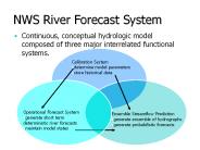
Ensemble Streamflow Prediction generate ensemble of hydrographs generate probabilistic forecasts Operational Forecast System
| PowerPoint PPT presentation | free to download

Title: Journ e mondiale de l'hydrographie Author: YG Last modified by: Bruno Frachon, SHOM Created Date: 10/29/2005 6:27:29 AM Document presentation format
| PowerPoint PPT presentation | free to download

... U.S. Geological Survey Water ... we send hydrographers into the field every 6-8 weeks to make flow ... Channel bathometry is also very difficult to map ...
| PowerPoint PPT presentation | free to download

Unsteady flow simulation(10 non-raining days) Compare the outflow hydrograph with the actual hydrograph ... 2D plan view (DOP) Calculate location of the thalweg ...
| PowerPoint PPT presentation | free to download

this information is based on iho special publication s-47 6th edition marchc 2006 more details for training courses could be consulted on iho special publication s-47 ...
| PowerPoint PPT presentation | free to download

The European hydrographic equipment market is estimated at $493.55 million in 2014, and is expected to reach $568.67 million by 2019 at a CAGR of 2.39% during the forecast period.
| PowerPoint PPT presentation | free to download
Can we afford rivers and lakes and streams and oceans which ... Isochrone of. Equal time to outlet. Time, t. Excess Rainfall. 0. 5. 10. 15. 20. Time, t. Area ...
| PowerPoint PPT presentation | free to download