
Geographic Radius PowerPoint PPT Presentations
All Time
Recommended

RADIUS What it is Remote Authentication Dial-In User Service A client/Server security Protocol Created by Livingston Enterprises Inc. An Internet draft protocol.
| PowerPoint PPT presentation | free to download
RADIUS What it is Remote Authentication Dial-In User Service A client/Server security Protocol Created by Livingston Enterprises Inc. An Internet draft protocol.
| PowerPoint PPT presentation | free to download

the routing protocols we discussed so far may not scale to large ... Right-hand rule results in the long detour x-u-z-w-u-x. 10. Removing Cross Edges. u. z ...
| PowerPoint PPT presentation | free to view
A client/Server security Protocol Created by Livingston Enterprises ... Features, Enhancements and distributions. Security. Flexibility. Simplified management ...
| PowerPoint PPT presentation | free to download

Assume we have algorithm X that takes as input a realizable globally rigid ... other 'virtual coordinate' systems such Vivaldi as an Internet coordinate system ...
| PowerPoint PPT presentation | free to view

Providing conceptual schemas for describing and manipulating the spatial characteristic ... Lake = AreaFeature featureType='Hydrography::WaterBody', extent = S3 ...
| PowerPoint PPT presentation | free to view

The interest in geography ' ... The interest in geography. X. Y. Find by distance. We know the location of A (X1, Y1) ... Geography::NationalGrid. Subclassable ...
| PowerPoint PPT presentation | free to view

Find Local Stores/ Distributors/ Offices / Salesmen by entering a 5 digit zip code. Results are displayed all from a database based on geographic proximity ...
| PowerPoint PPT presentation | free to download

Swartz' Entropy Test, 1998. Conradt's Segregation Coefficient, 1998. Perry's T, 1998 ... Swartz's Entropy Test. The test statistic is defined as. Tango's ...
| PowerPoint PPT presentation | free to view
Geographic Informatics in Health Maged N Kamel Boulos PhD, MSc, MBBCh School for Health, University of Bath Bath BA2 7AY, UK E-mail: M.N.K.Boulos@bath.ac.uk
| PowerPoint PPT presentation | free to download
School for Health, University of Bath. Bath BA2 7AY, UK. E-mail: M.N.K.Boulos@bath.ac.uk ... The concept that location can influence health is a very old one ...
| PowerPoint PPT presentation | free to download
... each known cholera case on a street map of Soho district (where the outbreak ... The Broad Street pump (shown in the centre of the map) proved to be the source ...
| PowerPoint PPT presentation | free to download

u. v. h. To ensure connectivity on the grid, add grid nodes in the cone. h = 0.223. ? = 0.37 ... Connectivity on the network. Connectivity on the virtual grid ...
| PowerPoint PPT presentation | free to view

ESnet RADIUS Authentication Fabric. Report on RADIUS-OTP feasibility study ... RADIUS Authentication Fabric. Solution to the OTP interoperability problem ...
| PowerPoint PPT presentation | free to view

... if high, increasingly steeper slopes are less likely to urbanize. ... the final location of this temporary urbanized cell is then considered as a new ...
| PowerPoint PPT presentation | free to view

Geographic Informatics in Health Maged N Kamel Boulos PhD, MSc, MBBCh School for Health, University of Bath Bath BA2 7AY, UK E-mail: M.N.K.Boulos@bath.ac.uk
| PowerPoint PPT presentation | free to download

Zip-codes. Area-codes. On Site Level. Whois. Business ... Area code. SEARCH. 13. Dynamic Geographic-IR. Replacing the 'next' button. Closer. Continue ...
| PowerPoint PPT presentation | free to view
Dr. Marina Gavrilova * Numerical scales of Geary s Ratio and Moran s I Spatial Patterns Geary s C Moran s I Clustered pattern in which adjacent or nearby ...
| PowerPoint PPT presentation | free to download

Programming for Geographical Information Analysis: Core Skills Lecture 3: Program Flow I Loops and Branches
| PowerPoint PPT presentation | free to download

An introductory lecture on Geographic Location and Map Projections
| PowerPoint PPT presentation | free to download

Overview of the RADIUS Tool - Simple Damage Estimation Software - Carlos Villacis, Ph.D. Software Purposes To facilitate preliminary estimation of earthquake damage ...
| PowerPoint PPT presentation | free to view

Arizona Geographic Information Council 2002 AGIC Conference
| PowerPoint PPT presentation | free to view
Ad-Hoc Nets: The Dream. Nodes forward each others' packets. ... Linux, Click, 802.11 radios. Aiming for campus-wide deployment. ...
| PowerPoint PPT presentation | free to download

Geographical Routing Using Partial Information for Wireless Ad Hoc Networks Rahul Jain, Anuj Puri, and Raja Sengupta University of California, Berkeley
| PowerPoint PPT presentation | free to view

Using Geographical Information System tool in containing influenza pandemic threats Republic of Lebanon Ministry of Public Health Epidemiological Surveillance Program
| PowerPoint PPT presentation | free to view

A tessellation of a plane is the filling of the plane with repetitions of ... The result is a tessellation of the plane into a set of regions called ordinary ...
| PowerPoint PPT presentation | free to view

Easy location of geographic variables. Links to external maps used to ... New England /r:GeographyName /r:GeographyValue External maps. Other Materials ...
| PowerPoint PPT presentation | free to view

Sensor Network Data is typically interpreted based on a sensor's location ... Beam Forming (Algorithms, Antennae) Experimental Results. Figure 2. Packet Throughput ...
| PowerPoint PPT presentation | free to view

An introductory lecture on Geographic Location and Map Projections
| PowerPoint PPT presentation | free to download

Exploring Spatial Patterns of Disease with Geographic Information Systems
| PowerPoint PPT presentation | free to view

Start with the category of the largest towns ... less than 100 bytes on average after simplification. 0-badewanne.baby--shop.de. Geo Propagation ...
| PowerPoint PPT presentation | free to view

Title: Elements of Hazard Analysis Author: Carlos Villacis Last modified by: Carlos Villacis Created Date: 5/20/2000 1:58:19 PM Document presentation format
| PowerPoint PPT presentation | free to view

The Potential of Geographic Information Systems to Facilitate Data-Driven Prevention: The Case of Tobacco National Prevention Network Annual Conference
| PowerPoint PPT presentation | free to view

Applications in GIS/Geographic Data Analysis. Lecture 6: Point Interpolation ... Fits a piece-wise polynomial function to a neighborhood of sample points ...
| PowerPoint PPT presentation | free to view

How does DNF apply to '''' Keith Murray, Chair of the DNF Expert Group Royal Geographical Society, L
| PowerPoint PPT presentation | free to view

Adam Walsh Legislation. Liane Moriyama. Hawaii Criminal Justice Data Center ... Reverse Lookup. NSOPR. Notification/List Serve. Geographic Radius ...
| PowerPoint PPT presentation | free to download

... place of work, and flows between home and work ... Mileage radius. Geographical boundary (Census Tract, TAZ) (preferable) ... in First Cities ...
| PowerPoint PPT presentation | free to download

Attributes that are continuously variable and measurable across ... peaks, pits, saddles, ridges, valleys, and flat plains. 5. Catchments and Drainage Networks ...
| PowerPoint PPT presentation | free to view

... Auckland Inc a brief history. 1963 incorporated as The Auckland Sheltered ... Geographic region from Albany to Pukekohe (50km radius from Central Auckland) ...
| PowerPoint PPT presentation | free to view

Specifying outcome-sensitive models of the consequences of segregation in U.S. cities ... Divide block map into 50x50m cells, and estimate racial group counts for each ...
| PowerPoint PPT presentation | free to view

Teaming Trends for Better Brokerage. Saturday, November 15, ... Large Geographic Trade Area (2 hour radius of Harrisburg, PA) Staff of 4 full time assistants ...
| PowerPoint PPT presentation | free to view

... of a specified radius or a prolate ellipsoid with specified values for the ... A Geographic Coordinate System (GCS) assigns unique coordinate values to ...
| PowerPoint PPT presentation | free to download

Introduction to Geographic Information Systems and Sample Applications
Two Points. Single Point. Geographic Coordinates (f, l, z) ... Geographic coordinates (decimal degrees) Projected coordinates (length units, ft or meters) ...
| PowerPoint PPT presentation | free to download

In local algorithms, nodes must decide only using local knowledge. ... Algorithms also work if interference radius transmission radius ...
| PowerPoint PPT presentation | free to view

868 MHz Modems. Required Fresnel Zone Radius. 2.4 GHz Modems. Required Fresnel Zone Radius ... 915 MHz. Regulatory Bodies. FCC (United States) IC (Canada) ETSI ...
| PowerPoint PPT presentation | free to view

Basic Geodesy and Geographic Coordinate Systems What is Geodetic Leveling ? Vertical surveying is the process of determining elevations above mean sea-level.
| PowerPoint PPT presentation | free to download

Changes from IP level to application level ... for the routing system. Receive incoming geographic messages. Store duration of lifetime ...
| PowerPoint PPT presentation | free to view

Geofencing advertising services is a location-based marketing service that sends push notifications to Smartphone users who enter a defined virtual geographic area.
| PowerPoint PPT presentation | free to download

Title: Geographic Informatics in Health Author: dk708 Last modified by: Emachines D725 Created Date: 1/21/2002 11:09:24 AM Document presentation format
| PowerPoint PPT presentation | free to view
Geofence mobile advertising mean finding all mobile devices in a given geographic area and serving mobile advertisements via app banners and mobile website ad space.
| PowerPoint PPT presentation | free to download
Geofence mobile advertising mean finding all mobile devices in a given geographic area and serving mobile advertisements via app banners and mobile website ad space.
| PowerPoint PPT presentation | free to download
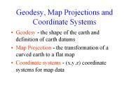
Map Projection - the transformation of a curved earth to a flat map ... GPS location of Mabel Lee Hall. Geographic Coordinates (f, l, z) ...
| PowerPoint PPT presentation | free to download

The decomposition of the region into four(4) can be resprensented as a ... Computer-aided design. Computer graphics. Databases. Geographic Information Systems ...
| PowerPoint PPT presentation | free to view
Overall differences between corpora and contributions of individual ... age, social class (Rayson, Leech and Hodges 1997), diachronic, geographical location. ...
| PowerPoint PPT presentation | free to download

The plots show that SA causes 95% of the points to fall within a radius ... Also shows distance. RAIM Prediction. Altitude Assist ... Runway Limits. SUA ...
| PowerPoint PPT presentation | free to download